| Wes Boyd's Spearfish Lake Tales Contemporary Mainstream Books and Serials Online |

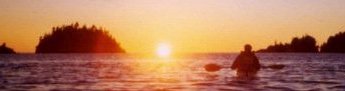
Las Vegas and the South Rim
|
| Wes Boyd's Spearfish Lake Tales Contemporary Mainstream Books and Serials Online |
3:09 AM is a horrible time to get up, any way you cut it, even though I tried to go to bed early the evening before. However, things were pretty well organized, and Kathy and I were on the road for Detroit Metro by 3:20. We arrived at Metro plenty early; it was still dark, although there was a noticeable lightening to the overcast in the east.
It was the first time I'd been near the new Northwest terminal there, and it took some figuring out how to even get to the passenger dropoff. There's a lot more hiking around in the terminal than there was in the old one, but I finally found the departure gate only to find that they moved it halfway up the terminal, so more hiking was involved. It was light by the time I got on the plane, and we blasted off though the broken overcast and got on top quickly, to where the sun was shining. Through breaks in the overcast I could see Chicago and the Mississippi River, but we were near the Kansas-Colorado line before it cleared off and stayed that way for real. From the sky it looked like there was some pretty country down there although from the years I'd spent there before, I knew that it was an arid semi-desert. We went right over Denver, and we must have gone pretty much over Leadville, where I was a flight instructor thirty years before; I could pick out Fairplay and Twin Lakes off to the left of the plane. From there on west it was arid country, most of which I had explored but little, even when I was there before, although some of it was quite rugged and pretty. From the air I could pick out the La Sil and Henry Mountains, still showing snow, roughly near Moab in eastern Utah, and could pick out Desolation Canyon -- a possible place to go sometime -- and could just make out Lake Powell well to the south. I got a good view of the chaotic country of Grand Staircase-Escalante before we turned slightly to the southwest and headed for Las Vegas. Off to the east, I could see the Grand Wash Cliffs, the end of the Canyon, and then we were flying into Las Vegas, laying flat and dusty in a wide, dry valley.
You easily know you're in Las Vegas -- the moment you walk off the jetway and into the terminal there's a row of slot machines. The terminal was not terribly busy, and I managed to find my way to the Payless Car Rental counter without too much difficulty. I had already reserved a rental car; it took a few minutes to get the paperwork arranged, and then I caught a shuttle bus out to the rental car parking area. There, waiting for me, was a bright red Kia Rio, the keys already in it. It took a few minutes to check it out, and soon I was on my way to the Hawthorne Suites, near the Strip. It's a very nice hotel, a little pricy, perhaps, for what I needed it for, but I've spent much more money for worse motel rooms. I checked in, picked up the gear box that I'd sent by UPS a couple weeks earlier, took it around to my room and dumped it on a table, along with the carry-on daypack I'd brought on the plane. I broke it open, got out a couple rolls of film and a couple other things I'd need, then left the rest of the stuff sit while I went out, got in the Kia, and headed out. The best route out to the four-lane took me down the south part of the Strip, and I caught a glimpse of some of the storied casinos I'd often heard about, impressive and overstated to the point of being obnoxious, although I didn't slow down much and gave much of my attention to the map.
On my way out of town, I confirmed my initial impression that Las Vegas is a town best seen in the rear view mirror. It has a distinct boom-town atmosphere; on the strip rather gaudy and garish and overdone, but rather nondescript and dusty in the suburbs, which seem to consist of a lot of new housing developments with houses jammed in on top of each other, with lots of bare dirt and rock in between. It's a real good example of why I don't like cities.
 |
|
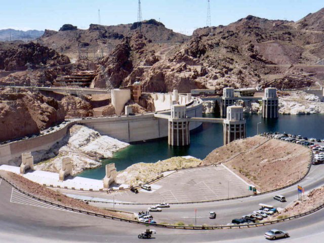
Hoover Dam. The level of Lake Mead is way down, as can be seen by the "bathtub ring" to the right of the towers. |
The traffic was heavy out US-93 over Railroad Pass to the southeast; I ran through Henderson and Boulder City, and out toward Hoover Dam and Lake Mead. The road gets to be 2-lane here, and there are plenty of signs that trucks and buses can't cross the dam for security reasons. Hoover Dam is a major tourist attraction in the area -- some people have to take a break from the slot machines -- and the place was crowded. I had to make a brief stop at a security checkpoint, and after crossing over the dam made a brief stop at an overlook and snapped one frame, the first of the trip.
It's probably only ten or fifteen miles of two-lane out to where US-93 becomes four-lane, but it was a slow period, caught in a long line of cars following a motor home towing a big boat, seldom over 20 MPH. It was good to get out on the four lane and blast south though a wide, dry valley, with some nice hills on each side, but mostly filled with Sonoran Desert vegetation like barrel cactus, prickly pear, the occasional Joshua tree, sagebrush, and the like.
As I headed on to the southeast, I could see off in the distance various housing developments, mostly mobile homes or other small, cheap housing out in the middle of this nondescript desert. It was most of an hour before I got to Kingman. By now, I'd been going for about ten hours my time and I hadn't even had breakfast yet, so I pulled into a Wendy's, got a triple, noticed that the gas price was $1.49 -- not bad -- and got on Interstate 40 heading east.
The country from Kingman east is a little different, mostly running through pinion pine country, and a couple times raising up to the ponderosa pine country. I knew from my time in Colorado decades ago that elevation has a lot to do with ground cover -- the higher, the cooler, and plant coverage is different -- and I like the pinion and ponderosa country. There were some very nice views to be had, especially at a place called Fort Rock Road, about 40 miles east of Kingman, where the road was littered on both sides with jumbles of smooth rock.
Traffic wasn't real heavy along I-40, but again there were plenty of signs selling 5 to 40 acre "ranches", although I didn't see much sign of actual development. Now, this was a little different from the Sonoran Desert between Lake Mead and Kingman -- I could see having a little country house out in this country, which is very empty. Not far east of Kingman there's a sign, "No services for the next 55 miles" which proved to be at a place called Siegelman, and they were right, there's nothing much out there. I was pretty impressed; this was nice country, although I'll bet it gets colder than the lower Sonoran Desert country.
I got the impression that the Kia didn't have a big gas tank and the needle was sagging pretty low by the time I got to Williams. I pulled off at the first gas station I came to -- a Shell station, and found that gas was $2.18 per gallon -- highway robbery after the $1.49 at Kingman. But I wasn't in the mood to look farther for the sake of a few bucks, so filled the tank and hit the road, heading up Arizona 64 and later US-180 toward the airport at the south rim of the Grand Canyon. This started out in ponderosa around Williams, descended into pinion forest, and climbed up into ponderosa again as we neared the Canyon. Off to the east, the San Francisco Range stood high, with snowcapped peaks stark against the sky, which was filled with mare's tails and high overcast, making the day seem a little gray.
I had already made a reservation for a 3:30 PM flight with Air Grand Canyon for a flight over the Canyon. It was now only 2:30, and since I wanted to get back at a reasonable hour I checked with the woman behind the counter. She remembered me calling her a couple weeks before, and my comment that I planned to drive out and back from Las Vegas for the flight. Back then, she'd warned me that it was a five-hour drive, about 265 miles. Now, I told her that it was more like a four hour and 20 minute drive, assuming you drove 85 and 90 all the way. I asked if there were any possibility that I could get on an earlier flight, and sure enough, there was, so in not more than 15 minutes I was in the air in a Cessna 207, the first time I'd been in a single engine plane in 20 years. It seemed pretty familiar, not terribly different from the Cessna 182 I used to fly out of Leadville in a past lifetime. The pilot, whose name I didn't catch, said we'd be in for a bumpy ride, considering the wind, which was strong and had been all day, but in the air it really wasn't bad -- I've been in worse.
 |
|
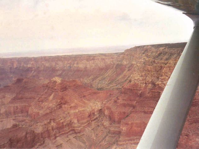
Flying out over the south rim of the Grand Canyon in an Air Grand Canyon Cessna 207. |
Also on the flight was a family from Japan, that didn't have much English, except for one woman who had a few words, so mostly I talked aviation with the pilot as we headed out over the ponderosa forest, avoiding the heavily visited areas for the sake of noise, before turning north and flying out over the rim and seeing the Canyon open wide before us. There was a little bump as we came out over the rim, but finally it opened wide and deep and spectacular, with the river a narrow thread a mile below, nearly lost in the chaos of rock. From this altitude, it didn't seem like much of a river. By now it was pretty overcast but parts of it were sunlit and spectacular. We followed the Canyon eastward to where the Little Colorado joined, its turquoise color standing out in contrast to the green of the river.
 |
|
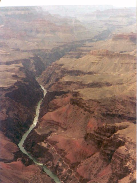
Checking out the rapids, roughly above the Little Colorado. I'll be down there soon! |
I was particularly impressed by the way that the back side of the south rim slopes sharply away from the Canyon. Geologically speaking, the river is much older than the Canyon -- the Canyon exists because a huge dome was thrust up from below in the fairly recent geological past, say four million years ago, about the time Lucy was walking the earth in Ethopia. The upthrust was to the north of the river, the center being up around Jacobs Lake on the Kaibab Plateau, and the canyon goes through the side of it, with the north rim, where I had been in 1998, a thousand feet or more higher than the south. Though we were well above the south rim, we were below the north rim, and you could see snow on the ground up in the Ponderosa there.
We flew back and landed -- it had been an interesting flight, and I was looking forward to seeing this country at ground level. Within minutes, I was back in the Kia and twisting its tail to the south. Remembering the small gas tank and the fact that I'd already put on a hundred miles since fueling, I stopped at a gas station north of Williams and topped off, this time at only $1.81 per gallon, then got back on the Interstate and headed west toward Kingman. Traffic was light and I moved right along, occasionally being blown around a little in the gusty southwest wind.
Since I was running ahead of schedule and didn't want to deal with the slow, dull trip up US-93 again, after a stop at Kingman to pick up a 12-pack of Miller Genuine Draft and a couple snack items, I turned west on Arizona 68 through Golden Valley -- another huge dusty trailer-packed development, this time pretty obviously something of a retirement community. The road wound up over a ridge, and down into the valley of the Colorado just south of Davis Dam, and entered Nevada again at Laughlin, a "mini Las Vegas" that's been filled with casinos in recent years, but the light was green and I didn't stop. I headed on up the other side of the valley on Nevada 168, and in a few miles reached US-95. Here, I did something a little special -- although I'd been in California before, I'd never driven there, so now I did -- south a couple miles to the California border sign, where I made a U-turn and headed back north.
By now, it was getting overcast, and the light was failing, so I headed north up US-95 at a pretty good clip. I came to one tiny town, Cal-nev-ari, which consisted of one moderate sized casino surrounded by mobile homes and RV parks. Oh, well, the more people pulling the handles on slot machines, the fewer crowding the natural wonders . . . on up to Searchlight, a little desert mining town, a bit grubby, and the only place that looked like a restaurant was also a casino -- this is Nevada, after all. Being a casino, the food was fast, if not particularly good; I called home briefly, ate quickly, and was back on the road again in the gathering evening. About 35 dull miles through a wide, dusty valley with low ranges on either side brought me back to US-93 at Henderson, and from there on it was fight the traffic back to Lost Wages.
I was a little surprised to manage to drive right to the car rental lot -- things were signed better than I expected -- and by now, it was getting dark. I left the Kia there, with a lot attendant that didn't speak English. The little car had done good service, 550 miles in 11 hours. It wasn't a car I particularly would have liked to have owned, but it did the job -- and at a daily rental of $16.75 plus gas, I couldn't complain about the cost. It was an interesting half day, time well spent.
I caught a ride back to the terminal on the Payless shuttle bus, where I got a taxi over to the Hawthorne. That was ten bucks by itself; guess we're back in Las Vegas, folks. I headed back to my room, reshuffled my gear into stuff I'd want on the river and stuff I'd want camping, and tried to organize things a bit. I was still wound up fairly tight after being up for something like 22 hours, so I got an expensive Coke from the machine, and went out by the pool in the dark, where I let the cool breeze wash over me while I could see the reflections of the gaudy lights of the Strip, unwound for a while, and headed in to bed.


