| Wes Boyd's Spearfish Lake Tales Contemporary Mainstream Books and Serials Online |

Las Vegas, Lee's Ferry, 19 1/2 Mile Camp
|
| Wes Boyd's Spearfish Lake Tales Contemporary Mainstream Books and Serials Online |
Since I had to get up at 4:30 after a long day and a short night, I both put in for a call from the front desk and set the alarm, but since 4:30 in Las Vegas was the same as my normal time of getting up of 7:30 in Michigan, my internal alarm clock won the battle and I was already getting around by the time the call came in. It didn't take long to get around; I'd already packed up stuff pretty well and laid out my clothes, so in only a few minutes I had the daypack over my shoulders and the handbag in my hand as I headed out into the predawn darkness.
It was just a short walk over to the lobby to where the group from Arizona River Runners was gathering. At least they had coffee and doughnuts awaiting, and I took a chance to stoke up before we left. There were already a few people there, including Dick Mattson, who is from ARR, but working on marketing. He had not run the river before, except for one of the three-day trips the company offers from Mile 188 on down. I'd talked with Dick on the phone about a couple of issues, and discovered him to be a good-looking, thirtyish guy with dark hair and a beard.
Everyone else was new to me, but I soon suspected I'd get to know a lot of people better. It was here that I met Kathy Johnson, who is a photo tech for the Boston Globe, and who intended to get a lot of photos -- she had 30 rolls of film with her, plus memory for about 1800 digital shots. Here too was the photo crew that I'd heard about, James and Marla Norris from Aristotle.net in Arkansas, who are redoing the Arizona River Runners web page (one of the weaker ones among the Colorado River raft companies) and their photographer, Jason Shivers, a lean guy with short, red hair and a number of Pelican cases filled with expensive camera gear, including a Nikon IPIX super-wide angle camera. He had a portable hard drive with him in all that stuff, and had close to an effectively unlimited memory, plus a digital video camera. I have no idea how much all that stuff was worth but one camera by itself was worth over $10,000, making my stuff seem pretty cheap by comparison.
There was quite a mix of people, none particularly young, and several people in their seventies. I figured that before the trip was over I'd get to know some of them a lot better -- although, to be honest, I never did get everybody's name to the point where I could remember it to use it. A little to my surprise, a majority of people on the trip were effectively locals, from California, Nevada, and Arizona, and only a relative few of us from the east, like Kathy, from Boston, and myself.
 |
|
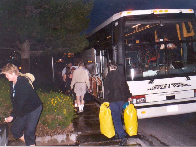
Loading up the bus before dawn in Las Vegas. |
We were supposed to get on the bus at 5:15, but wound up running late. It seems that there are two Hawthorne "hotels" in Las Vegas -- the Hawthorne Suites, where we were staying, and a Hawthorne something else, where sure enough, someone else had stayed. They didn't discover the error until that morning, and had an expensive taxi ride to meet up with the bus. We hopped on the big tour bus just as it was starting to get light, and headed down the street to a nearby convenience store so everyone could stock up on things like beer and other last minute items. As far as I know, no raft company, Arizona River Runners included, is licensed to sell or give away beer, but they do allow customers to bring their own, and we had a pretty good collection of suds on the bus.
It was light by the time we were on the bus and heading north. I didn't get the bus driver's name, but he was a big enough guy to make me look small, and pretty jovial. There was a PA system on the bus and he spent a lot of time talking about the places we were passing, a good tour guide. We spent a lot of time on the bus getting to know each other as we headed up Interstate 15, cut the corner across the extreme tip of Arizona, and into Utah. The sky was pretty overcast, and one time we got rained on fairly heavily. We made a brief pit stop at St. George, then on up to Hurricane (which the bus driver said was locally pronounced "Herkin"), where we met up with the track we had followed on our 1998 trip, and followed it backwards to Marble Canyon.
Several miles east of Hurricane we crossed back into Arizona at Colorado City, which has an interesting history. It's a Mormon polygamist community, probably one of the largest, and the driver told us that virtually everyone in the town is named "Barlow". It's got to be an interesting phone book! Although Utah Mormons have a history of polygamism in their distant past, the church and the state frown upon it now. The community got along fine for many years, until a movie was set in the town, and the story brought it to general attention. Utah had no choice but to lean on the people there -- so they moved the town across the highway, into Arizona. It seems that there's an interesting twist to the local tax laws -- a house under construction isn't taxed as heavily as one that's completed -- so the houses there are still under construction, some after thirty years or more. Every place seems to have a framed up room that isn't closed in, boarded up windows, and the like.
We headed on east up Arizona 389, through more Sonoran desert country, with low ranges of maintains to either side, and at Fredonia turned onto Alt. US. 69, which took us up through some pinion pine country into the Kaibab National Forest and a magnificent stand of ponderosas. At Jacobs Lake, we started heading back down through the pinions, and emerged in a wide valley with the colorful Vermilion Cliffs to the north. This range of steep, red cliffs extends for many miles, and we only saw a part of it as we went through the wide, dusty valley down to Marble Canyon, where we made another pit stop, this time to buy Arizona fishing licenses for the people that wanted to fish along the trip. I got off the bus for a cigarette, to discover that the wind was blowing, and blowing hard -- I estimated 30 mph. The sky was partly overcast, with an upper level cloudiness of more mare's tails, not boding well for the weather. The last time I'd checked the weather for the area, they were calling for a 30% chance of showers, and it had already proven that the forecast was correct.
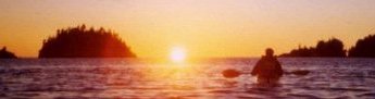
We got back on the bus and headed the five miles or so on down to Lee's Ferry. This drive is down through absolutely barren red rock, with no sign of vegetation to be seen, down across the little Paria River, which is a notorious flash-flooder and fills the Colorado with silt when it's running hard. We swung around a bend and got the first sight of the river that we'd be spending the next week on, running green through the red of the desert rock, and amazingly clear. The word "Colorado" comes from the Spanish, named for this river -- literally, "Red Color", but since the Glen Canyon Dam and Lake Powell filters out all the silt that comes from upstream and fills the reservoir with it, for the most part the Colorado runs a clear green -- and will for the next hundred years or two, when Lake Powell is filled with silt.
 |
|
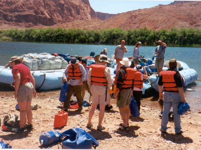
Packing the gear and getting orientation from Joe at Lee's Ferry. |
The bus came to a stop right by two large, light blue rafts sitting nosed to shore at the landing. We found out later that the rafts had come up partly disassembled on a semi-trailer the day before and that the crew had spent half the day the day before and part of this morning getting everything rigged and ready to go. We got off the bus, to discover several piles of life jackets (the term "PFD" isn't used) and drybags sitting there, each of the drybags with a number on them. We each picked out a pile and loaded our stuff into the drybags. There was a large one, for the gear we wouldn't want on the river, and a smaller one, for stuff that we wanted to get to during the day, like rainwear, spare film, sunglasses, and the like. I slipped my watch into the bottom of my duffle bag -- that was one thing I wouldn't want for the next week, and did a little gear reorganization. The big drybag proved to be larger than I had understood from the ARR literature, and my duffle bag slid into it easily, along with the fleece jacket I'd taken onto the bus with me in the early morning.
The trip leader introduced himself -- a shortish guy, lean and bearded, Joe Pollock. He would run one of the rafts; a taller guy, with short hair and a scrubby beard, Josh Winnicki, would run the other one. There was one "swamper" -- trainee raft guide and helper, a pretty, brassy, twentiesh looking, dark-haired, slender girl (we were later to learn she was actually 33 -- and had lost 70 pounds in the last year!) named Christine Parker, and universally called by her last name. There were also three unpaid helpers, one of whom was Parker's fiance, Lance Wine, and another Joe's future brother-in-law, Jay Rogers, and a third guy, Troy Braswell, who had worked with Parker in a ski shop and got invited along literally at the last minute.
 |
|
The wind was blowing hard up the river at Lee's Ferry. Rowing those oar boats on that private trip isn't going to be fun! |
Joe took some time to give us a brief orientation about what we were going to be doing -- he said there would be more later -- and we got on the boats. A trip from Grand Canyon Expeditions had already loaded and was leaving as we loaded up -- we'd play tag with them clear down to the end of the trip -- and a private trip, just getting set to load out in oar boats. While I envied the latter their private trip and oar boats, I couldn't help but think about what a bear it was going to be to be rowing those boats into the teeth of that howling wind that came up the river, making two-foot wind waves.
Orientation completed, we got on the rafts. As luck had it, I wound up on Joe's raft, in a spot back toward the back. The rafts, although rather ugly, were interesting -- they are a time-tested and proven design that has been stable for many years. The core is a single raft, over thirty feet long with tubes about three feet around, but with a wide opening at the back for a motor well and the boatmen's station. The central section of the raft has a steel frame to keep it from flexing, but it's in two parts that are not connected so that it can flex some. The flex point is covered with a lateral rubber tube about 18 inches across and about eight feet long, called a "weenie tube" and since it's a flex point it's not a good place to ride in the rapids. The load is so large that the single raft can't handle it very well, and the center of gravity is fairly wide, so there are "side tubes" about twenty feet long and three feet wide lashed to either side. The whole works is lashed together with ropes and straps, and the parts of the rafts are pretty interchangeable, especially the side tubes. Joe was to tell us later that ARR has five sets of two such rafts, with plenty of spare parts; the design is pretty stable, and he said that ARR has some side tubes sitting in their warehouse that are up to 40 years old. The rig is powered by a 30-hp four stroke Honda outboard, and a spare outboard is carried on each raft.
In the center of each raft are "boatmen's boxes" where various gear and food items are carried -- the duffel pile, mostly in drybags, is carried on top of this, and tarped down, the tarps cinched tight with straps; the personal daybags are snapped where they can be to the tarp straps. There are side boards running part way down the front of the tubes of the main raft, and these are, at least officially, the seats, although in normal conditions, people just perch where they can on the duffle pile.
So, with personal gear strapped on and everybody in place, the boatmen warmed up their outboards and we got under way. We headed out on the river, through the first rapid -- a small one called "Paria Riffle". From there, it was a last glance back to the landing at Lee's Ferry, and then it was around a bend and lost from sight. For the next week, there would be few signs of man.
One of the facts of life about these big rafts is that those big blunt bows aren't the driest thing in the world -- every time we hit a wave over about four inches high we got a spray of water thrown back up over the bow, and carried back to us in the teeth of the strong wind -- and we were bucking into two-foot wind waves! Even back in the back, it was pretty wet; even though it had been coolish, say, seventy or so, I'd put on my rainsuit jacket, more for protection from the wind than anything else, and soon found myself wishing I'd put on the rainpants as well.
 |
|
First lunch stop, not far below Lee's Ferry. |
But, we weren't out long. Soon, Joe picked out a likely sandbar, and nosed the raft into it, and Josh, wearing a big, white cowboy had, nosed himself in alongside. The crew and Parker ran lines to shore to tie up to a likely tamarisk tree, and the two rafts were strapped together. For as big as these rigs were in this wind it seemed like a fragile tiedown but they were pretty stable. In a few minutes, the crewmen had set up a couple of tables on the sand of the small beach, and were setting out bread, chips, and cold cuts for lunch. This was welcome, as most of us hadn't had much to eat since the doughnuts and coffee for breakfast a good six or seven hours before.
While we were eating, Joe spent some time talking about camp sanitation. Basically, that meant that we would be taking all solid waste out with us, and doing our best not to leave food scraps, which could draw red ants. We had a single toilet along with us, but it was only for solid waste. Called a "rocket box" or a "groover" (when the regulation was first put out, the initial answer was to use old army ammunition boxes, which lacked a seat -- and would put two grooves in your butt in the process), the toilet was an aluminum box with a sealed top, which could be removed and replaced with a simple toilet seat. To keep the smell down, we carried several on the trip, and they would get full. I imagine that one of the less likeable parts of a raftsman's life is to have to empty the groovers after the trip is over with -- especially in trips where the temperature is in the 90s, 100s, or even higher.
Urination, by Park Service rule, is to be in the river. There is no cover; the general rule is that men go upstream, and that women go downstream, and everyone exercises some courtesy. Still, that doesn't always work; rocks and mud along the river sometimes make some areas unusable. It's also possible to go back in the motor well, especially when under way, and once again a little judicious turning of backs is considered courteous. I was warmed a little by the thought that Las Vegas -- and Los Angeles -- get their water from this river.
 |
|
Yes, the Navajo Bridge does look better from below than it does above. Maybe someone up there is watching and wishing. |
After lunch, we got back out on the river. By now it was blowing even harder, straight up the river, and it was getting uncomfortable and wet as we got into the narrows of Marble Canyon, which was at least a little more protected, and there were few real rapids. After about five miles, we floated under Navajo Bridge -- and even considering the wind, and the now overcast skies, and the fact that it was a little chilly, it was a big point of the trip for me -- yes, those two slender steel arches in the sky look a lot better from below than from above.
Soon, Navajo Bridge was behind us. We floated down through the sheer walls of the narrow canyon. Here and there, the canyon wall was broken with a dry wash, cutting down through the rim, usually narrow and tortured, filled with scree and rock rubble. These do provide hiking routes down from the rim in this area, and twice we saw people that had hiked down from the rim near Marble Canyon to do some fishing.
 |
|
Marble Canyon below Navajo Bridge, heading for the first real rapids. |
About three miles below Navajo Bridge, at Mile 8, we came to the first real serious rapid -- Badger, about a "7" at this water level. The Canyon guides use a different system than the International Scale, which only goes to a VI. There's some debate about how the Canyon system equates to the International Scale, but in general, dividing the Canyon system by two comes out pretty close, although Joe said at one point that in his opinion there aren't any International Scale rapids above a IV in the Canyon, although he can find people with differing opinions. The difficulty of some of the rapids varies with the water level -- some get tougher as the water level gets higher, and others get easier.
In most cases, the rapids in the canyon are located where side canyons come in. After very heavy rains, some of these can run with a "debris flow" that's a concrete-like mass of mud, rocks and boulders. This sweeps out into the river and can create rapids, or drastically modify existing ones. A couple of nights later, down at Cardenas, Joe told us how last September he'd been out on the river when such a storm came along, creating two new small rapids in the area and modifying an existing one -- and, though small, he was among the first to run them.
Also, in most cases, the rapids neck down to a single area where the majority of the river pours through. Boatmen, reading from upstream, can see this "tongue" of smooth water, followed by a train of waves, sometimes several feet high. Occasionally, there are rocks in this tongue, making the possible route more difficult. Considering the size and weight of the boats -- over three tons-- maneuvering in the rapids to get out of the worst of the wave train is difficult and most often you just ride the wave train down -- which is a bucking, wet thrill ride, especially in bigger rapids.
In the smaller rapids, people just hang on where they happen to be perched on the gear load, but in the bigger ones, or the ones that require maneuvering and better visibility, the passengers have to get down on the sideboards, and not ride on the side tubes -- a position known as "down and in". A call from the boatman for "Down and In" was almost always a warning of a rough ride.
Badger was relatively short and relatively easy, although we got wet, the wind throwing us around quite a bit. A little farther on, at Mile 11, came Soap Creek. This was a longer ride that required some maneuvering, if slightly simpler, according to the guide. This was the last major rapid of the canyon to be run, in 1923; the water was running so high that the boatman didn't recognize where he was, and ran it before he figured it out.
As we ran on down the river, thrilling to the views, the sky became darker and thicker with clouds, and we could see the virga of rain hanging down. We ran a couple more small rapids, then came to House Rock Rapid, at Mile 17. This was the toughest one we hit all day, and we all got pretty wet, not comfortable on the cool, overcast day and with the wind blowing hard. Joe said he planned to camp just below House Rock, but got his signals crossed with Josh, who was too far downstream to make it back up to the campsite, so we ran onward. The next good spot to camp was at Mile 20, but when we swept around the corner, we could see the Grand Canyons Expeditions party already camped there.
 |
|
We discovered this group of mountain sheep in Marble Canyon near our camp at 19 1/2 Mile. |
Just at that point, some sharp eyes noticed a mountain sheep along the shore, and we came to a stop to look at it. They blend into the rocks pretty well, and were hard to pick out, but eventually we discovered two females and three kids. Joe idled the boat and headed into an eddy, where we could all get a good look at an amazingly close distance. The walls of the canyon here were pretty steep, but there was a rock rubble slope (called "talus") with a narrow sand beach below it, and the goats were messing around in a small wash.
Josh's raft came up alongside, and we both sat there for a few minutes, watching the sheep, while Joe looked back upstream for a ways. He scratched his beard a couple of times, finally said the words that I will remember him for, "Indecision is the key to flexibility," and eyed a small beach not far away. "I haven't stayed here before but it looks pretty good," he said, and ran back upstream for a short distance in the eddy, and pulled up on a sandbar at about 19 1/2 mile on river right. This was to be our home for the night. There was a large sandbar several feet above the river and about fifty yards long, and a higher shelf behind it, of looser talus, with sandy spots. Joe ran the bow of the raft up on the beach, with Josh right beside, and a couple of the crew ran out lines to tamarisk trees along the shore. We were cold and wet, and glad to be off the river.
 |
|
Duffle line unloading the rafts at the first night's camp, at about 19 1/2 Mile. |
Joe told us that once we were off the raft to find a place to spend the night. I really would have preferred to have been up in the rocks, away from the main part of the crowd, but didn't like the looks of the scramble in the soft sand, so settled for a spot on the main sand bar, only a few feet from the river, while others, more adventurous, decided on the upper level. They were picking out camp sites when someone noticed one of the sheep kids on that level, with the men between the kid and the rest of the sheep, so we called them down so the sheep could rejoin the main group. These sheep, anyway, weren't very wary.
Down on the beach, Joe gave a demonstration of how to set up the tents. These were Keltys, good tents, but they'd been used a bit and a straight pole was virtually unknown. I had already decided that I planned to sleep out under the stars so long as it didn't look like rain, but it was obviously going to rain -- it had spit a few drops already -- so pulled a tent out of the four tent bags we carried and went to setting it up. It was not easy; the poles were rather tight but with the help of another passenger we managed to get the tent up. I stuffed my gear inside, and a light rain started -- it would rain off and on lightly for the next several hours.
 |
|
Unloaded rafts at 19 1/2 Mile campsite, ready for the day tomorrow. |
Inside the tent, I got out of my wet clothes, and pulled on the polarfleece warm suit I'd brought with me -- it felt good -- and started to organize my gear while the boatmen set up a tent fly and started dinner under it. Dinner was halibut and rice, and only served in a gathering darkness with low, cold, wet clouds hanging overhead. I had little more than finished with dinner when it was dark enough to get thinking about going to bed.
I hadn't been in the warm, comfortable sleeping bag long when a strong wind came up -- it could have been as strong as forty or fifty, and it just wrapped the tent around me, although amazingly it stayed standing -- it must have been a better tent than my initial impression, although it was easy to understand why it had bent poles. With the rain came a hard rain, but I just pulled the bag over me and tried to get to sleep.


